
Everest Trek Map (2026): Route, Elevations, Distances & Itinerary Planner
Updated October 2026 · Written in Kathmandu · Heights in feet (metres in brackets) · Permit and Lukla flight rules checked for the 2026 seasons
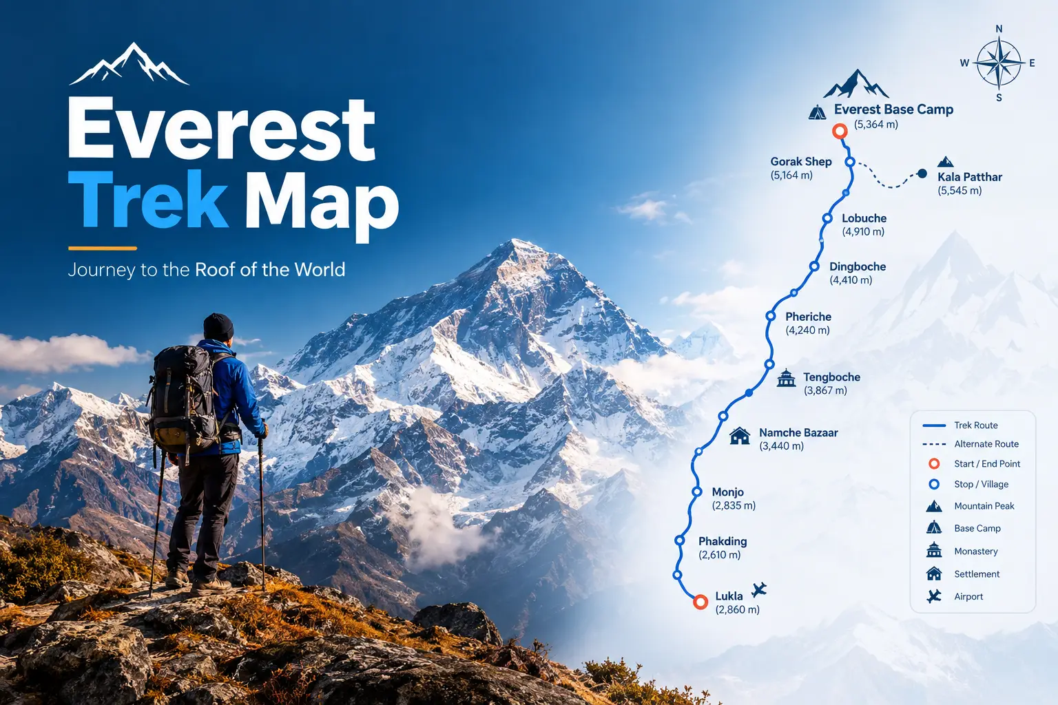
Most Everest trek maps online are either a pretty route image on a tour company’s sales page or a product listing for a paper sheet map. Neither tells you what you actually need on the trail: how high you sleep each night, how far the next village is, where the permit checkpoints are, where the last ATM is, and which junctions send trekkers the wrong way.
This page is built as a working Everest trek map tool. It maps the whole Khumbu trail network, lets you open each stop for details, checks every day’s altitude gain against safe-ascent guidelines, and gives you ready-made 12, 14 and 16-day plans. If you are still at the stage of visas, SIM cards and insurance, start with our complete guide to traveling to Nepal, then come back here to plan the trek itself.
The Everest trek map in one paragraph
The classic route flies into Lukla (9,383 ft), walks up the Dudh Koshi valley through Phakding and the park gate at Monjo to Namche Bazaar (11,286 ft), climbs past Tengboche Monastery to Dingboche (14,469 ft), then follows the Khumbu Glacier via Lobuche and Gorak Shep to Everest Base Camp (17,598 ft). The highest point most trekkers reach is Kala Patthar (18,192 ft). The round trip is roughly 75–80 miles and usually takes 12–14 days including two acclimatization days.
Tool sections
- The full Everest trek map (all three valleys)
- Trail junctions where trekkers go wrong
- Stop-by-stop finder
- Elevation profile and altitude-gain checker
- Distance and walking-time table
- Itinerary planner: 12, 14 and 16 days
- Everest region routes compared
- Getting to the start: Lukla, Ramechhap and road options
- Permits and checkpoints on the map
- Best printed and offline Everest maps
- FAQs
Everest Trek Map: The Full Khumbu Route Network
Above Namche Bazaar the Everest region splits into three parallel valleys. The classic Everest Base Camp trek uses the middle one. Gokyo Lakes sits in the western valley, and Chhukung and Island Peak sit in the eastern one. Three high passes link them, which is how the Three Passes trek and the Gokyo–EBC loop are built. Read each column from the bottom (lowest) to the top (highest).
Everest region trek map (schematic, not to scale)
West: Gokyo Valley
Dudh Koshi · Ngozumpa Glacier
Gokyo Ri · 17,575 ft
Gokyo · 15,715 ft
Machhermo · 14,665 ft
Dole · 13,255 ft
Mong La · ≈13,000 ft
Middle: Khumbu Valley (classic EBC)
Khumbu Khola · Khumbu Glacier
Kala Patthar · 18,192 ft
Everest Base Camp · 17,598 ft
Gorak Shep · 16,942 ft
Lobuche · 16,207 ft
Thukla (Dughla) · ≈15,100 ft
Pheriche · ≈14,340 ft
Pangboche · ≈13,070 ft
Tengboche · 12,687 ft
East: Imja Valley
Imja Khola · Island Peak
Island Peak summit · 20,305 ft
Chhukung Ri · ≈18,200 ft
Chhukung · 15,518 ft
Nangkartshang viewpoint · ≈16,700 ft
Dingboche · 14,469 ft
Gokyo ↔ Lungden ↔ Thame (west side)
Gokyo (Thagnak) ↔ Dzongla ↔ Lobuche
Chhukung ↔ Lobuche (east side)
Shared trunk trail (all routes)
Lukla 9,383 ft → Phakding 8,563 ft → Monjo 9,301 ft (park gate) → Jorsale → Hillary Bridge → Namche Bazaar 11,286 ft → Sanasa / Kyangjuma (the trail splits: right for Tengboche and EBC, left up to Mong La for Gokyo)
Elevations are rounded and vary slightly between maps (published Kala Patthar figures range from about 18,190 to 18,520 ft depending on the survey point). Always navigate with a scale map or offline app.
Trail junctions where trekkers go wrong
The Everest trail is busy and well marked, but four junctions catch people out every season, especially in fog or when walking ahead of a group. These are the points to zoom into on any Everest trek map:
The contour path from Namche reaches a fork near Sanasa and Kyangjuma. Descend right toward Phunki Thenga for Tengboche and EBC; climb left to Mong La for Gokyo.
The trail splits for Dingboche (Imja valley, right) or Pheriche (Khumbu valley, straight on). Both rejoin at Thukla, so either works – but your lodge booking may be in only one.
A steep climb above Thukla leads to the climbers’ memorial cairns. Here the Dzongla and Cho La trail branches west; stay on the valley path to Lobuche.
Beyond Gorak Shep the base camp path follows a shifting glacier moraine. Kala Patthar is the slope directly behind the lodges, not along the glacier – don’t mix the two up before dawn.
Stop-by-Stop Finder: Tap Any Village for Details
Each stop below opens to show its height, what services you can realistically expect, and what it means for your plan. Services in the high villages change with the season and the lodge, so treat these as typical rather than guaranteed.
Lukla · 9,383 ft (2,860 m) — trek start
- Tenzing–Hillary Airport; flights from Ramechhap in peak season, Kathmandu at other times
- Buy your Khumbu Pasang Lhamu Rural Municipality permit here
- ATMs, gear shops, bakeries and the last big choice of supplies before Namche
- Meet porters here; repack to the airline weight limit before you fly in
Phakding · 8,563 ft (2,610 m) — first night
- About 3–4 hours from Lukla, mostly downhill along the Dudh Koshi
- Lower than Lukla, so a gentle first night for your body
- Plenty of lodges; many groups push on to Monjo to shorten the Namche climb
Monjo · 9,301 ft (2,835 m) — national park gate
- Sagarmatha National Park entry checkpoint; buy or show your park permit
- Sleeping here instead of Phakding cuts the next day’s gain to Namche by about 740 ft
- After Jorsale comes the long climb to the Hillary suspension bridge and Namche
Namche Bazaar · 11,286 ft (3,440 m) — acclimatization day 1
- The Sherpa capital: last reliable ATMs, pharmacies, gear rental, bakeries, good phone signal
- Rest-day hikes to the Everest View Hotel area or Khumjung and Khunde (Khunde has a hospital)
- Saturday market and a small Sherpa museum above town
- Withdraw enough cash here for the rest of the trek – above Namche it is cash only
Tengboche · 12,687 ft (3,867 m) — the monastery
- Tengboche Monastery, the largest in the Khumbu, with views of Ama Dablam and Everest
- Few lodges on the ridge; nearby Deboche, a short walk on, has more beds and is slightly lower
- The day involves a big descent to Phunki Thenga before the climb, so total effort is more than the net gain suggests
Dingboche · 14,469 ft (4,410 m) — acclimatization day 2
- Stone-walled fields in the Imja valley; above the tree line from here on
- Rest-day hike up Nangkartshang ridge or out to Chhukung to climb high and sleep low
- Charging, hot showers and Wi-Fi cost noticeably more from here upward
Pheriche · ≈14,340 ft (≈4,371 m) — the medical village
- Home of the Himalayan Rescue Association aid post, usually staffed in the main seasons
- Alternative to Dingboche on the way up and the usual first stop on the way down
- Windier valley floor; check in at the aid post if anyone in your group has symptoms
Lobuche · 16,207 ft (4,940 m)
- A small cluster of lodges beside the Khumbu Glacier moraine
- Nights are very cold; book ahead in October and April, when beds run out
- Cho La trekkers arrive here from Dzongla to the west
Gorak Shep · 16,942 ft (5,164 m) — last lodges
- The final settlement, on an old frozen lake bed; base for both EBC and Kala Patthar
- Most people sleep badly here – one night is usually enough
- Arrive by lunch, drop your bag, walk to base camp in the afternoon
Everest Base Camp · 17,598 ft (5,364 m)
- About 2–3 hours one way from Gorak Shep along the glacier moraine
- The marked rock and prayer flags are at the trekkers’ end; the expedition tents are spread across the glacier in spring
- You can’t see Everest’s summit well from here – that’s what Kala Patthar is for
Kala Patthar · 18,192 ft (5,545 m) — best Everest view
- A steep 1.5–2 hour climb from Gorak Shep; most go for sunrise or late-afternoon light
- The highest point of the classic trek and the classic photo of Everest, Lhotse and Nuptse
- Pre-dawn temperatures are well below freezing – carry your warmest layers and a headlamp
Elevation Profile of the Everest Trek (Round Trip)
This profile shows where you sleep (or stand, for EBC and Kala Patthar) on each step of the standard 12-day trek, including the descent. Darker bars mean higher altitude.
Phakding
Namche
Tengboche
Dingboche
Lobuche
Gorak Shep
EBC
Kala Patthar
Pheriche
Namche
Lukla
Heights in thousands of feet. Going up takes about eight days; coming down takes about three.
Altitude-gain checker: how hard is each day?
Mountain-medicine guidelines advise that above about 9,800 ft (3,000 m) you should raise your sleeping altitude by no more than about 1,640 ft (500 m) a night, with a rest day every three or four days. Here is how the standard itinerary measures up. This is something almost no route map shows you.
Green: within the 1,640 ft guideline. Orange: slightly above it. Red: well above it – only acceptable because a rest day follows.
How to fix the red and orange days
- Sleep at Monjo, not Phakding, on day 1. The Namche day drops to about +1,985 ft.
- Never skip the Namche rest day, however good you feel. It exists because day 2 is the steepest gain of the trek.
- Add a night at Pheriche or Thukla on the way up if anyone has a headache at Dingboche.
- If symptoms get worse, go down. Confusion, stumbling or breathlessness at rest are emergencies, not something to sleep off.
Everest Trek Distance and Walking-Time Table
Distances on the Everest trail are quoted very differently from one source to the next because GPS tracks wander on switchbacks. The figures below are typical stage values; the walking times matter more than the miles, because altitude, not distance, sets your pace.
| Stage | Distance | Walking time | Running total |
|---|---|---|---|
| Lukla → Phakding | ≈5 mi (8 km) | 3–4 h | 5 mi |
| Phakding → Namche Bazaar | ≈6.3 mi (10 km) | 5–6 h | 11.3 mi |
| Namche → Tengboche | ≈5.7 mi (9 km) | 5–6 h | 17 mi |
| Tengboche → Dingboche | ≈6.8 mi (11 km) | 5–6 h | 23.8 mi |
| Dingboche → Lobuche | ≈5.5–7.5 mi (9–12 km) | 5–6 h | ≈30 mi |
| Lobuche → Gorak Shep | ≈2.8 mi (4.5 km) | 3 h | ≈33 mi |
| Gorak Shep → EBC (one way) | ≈2.2 mi (3.5 km) | 2–3 h | ≈35 mi |
| Gorak Shep → Kala Patthar (one way) | ≈1.2 mi (2 km) | 1.5–2 h up | side trip |
| Gorak Shep → Pheriche | ≈7 mi (11–13 km) | 5–6 h | descent |
| Pheriche → Namche | ≈12 mi (19–20 km) | 6–7 h | descent |
| Namche → Lukla | ≈11 mi (17–18 km) | 6–7 h | finish |
One way to base camp is about 35–40 miles of trail; with the descent, Kala Patthar and acclimatization hikes, most trekkers log roughly 75–80 miles in total.
Itinerary Planner: Pick Your Route Length
Open the plan that matches your time. All three count trekking days from the morning you fly into Lukla. Add at least one spare day before your international flight for Lukla weather.
12 days · Classic Everest Base Camp (most popular)
| Day | Route | Sleep |
|---|---|---|
| 1 | Fly to Lukla, walk to Phakding | 8,563 ft |
| 2 | Phakding → Namche Bazaar | 11,286 ft |
| 3 | Rest day: hike toward Khumjung, return | 11,286 ft |
| 4 | Namche → Tengboche | 12,687 ft |
| 5 | Tengboche → Dingboche | 14,469 ft |
| 6 | Rest day: Nangkartshang hike, return | 14,469 ft |
| 7 | Dingboche → Lobuche | 16,207 ft |
| 8 | Lobuche → Gorak Shep → EBC → Gorak Shep | 16,942 ft |
| 9 | Kala Patthar sunrise, descend to Pheriche | ≈14,340 ft |
| 10 | Pheriche → Namche | 11,286 ft |
| 11 | Namche → Lukla | 9,383 ft |
| 12 | Fly out of Lukla | Kathmandu |
14 days · Gentler EBC (best for first-timers and older trekkers)
- Day 1: Lukla → Monjo (9,301 ft)
- Days 2–3: Monjo → Namche, then rest day
- Day 4: Namche → Deboche or Tengboche
- Days 5–6: To Dingboche, then rest day (Chhukung hike)
- Day 7: Dingboche → Thukla (a short day that splits the climb to Lobuche)
- Day 8: Thukla → Lobuche
- Day 9: Gorak Shep and Everest Base Camp
- Day 10: Kala Patthar, descend to Pheriche
- Days 11–12: Pheriche → Namche → Lukla
- Days 13–14: Fly out, plus one weather buffer day
16 days · Gokyo Lakes + Cho La + Everest Base Camp loop
- Days 1–3: Lukla → Phakding → Namche, rest day
- Days 4–6: Namche → Dole → Machhermo → Gokyo (short, safe gains)
- Day 7: Sunrise on Gokyo Ri (17,575 ft), rest at Gokyo
- Day 8: Cross the Ngozumpa Glacier to Thagnak (Dragnag)
- Day 9: Cross Cho La (17,782 ft) to Dzongla – the hardest day; start before dawn
- Day 10: Dzongla → Lobuche
- Day 11: Gorak Shep and Everest Base Camp
- Day 12: Kala Patthar, descend to Pheriche
- Days 13–14: Pheriche → Namche → Lukla
- Days 15–16: Fly out, plus buffer. Doing Gokyo first means you are well acclimatized before the pass.
Everest Region Trek Routes Compared
The same map supports several very different treks. Use this table to decide which line you are actually drawing.
| Route | Days | Highest point | Who it suits |
|---|---|---|---|
| Classic EBC | 12–14 | 18,192 ft (Kala Patthar) | First high-altitude trek, fit walkers |
| Gokyo Lakes & Gokyo Ri | 11–13 | 17,575 ft | Quieter trails, turquoise lakes, arguably a better Everest view |
| Gokyo + Cho La + EBC | 15–17 | 18,192 ft | Experienced trekkers wanting both valleys in one loop |
| Three Passes | 18–21 | 18,192 ft (Kongma La 18,159 ft) | Strong, experienced trekkers; passes can close in snow |
| Jiri or Shivalaya walk-in to EBC | 19–22 | 18,192 ft | The historic Hillary approach; skips the Lukla flight and acclimatizes naturally |
| Jeep via Salleri to Paiya or Thamdanda | +2–4 days | same as chosen route | A road alternative when Lukla flights are cancelled for days |
Getting to the Start of the Map: Lukla, Ramechhap and Road Options
The first line on any Everest trek map is the flight. In the spring and autumn peak seasons, scheduled Lukla flights do not leave from Kathmandu. Nepal’s Civil Aviation Authority moves them to Manthali Airport in Ramechhap, roughly 82 miles (132 km) by road east of Kathmandu, to ease congestion. Trekking companies commonly describe the window as late March to the end of May and late September to the end of November.
- Off-season (winter and the monsoon), flights often return to Kathmandu, but check with your airline.
- Weather rules everything. Lukla flights fly by sight, and cloud can ground them for one to three days in a row.
- Baggage is strict – plan on about 22 lb (10 kg) checked plus a small carry-on.
- Backups: shared helicopters from Ramechhap or Kathmandu, or a jeep through Salleri to the Paiya and Thamdanda road-heads, then walk up to Lukla’s trail.
Permits and Checkpoints on the Everest Trek Map
The Everest region needs two local permits and no TIMS card. Both checkpoints sit on the first two days of the map, so you cannot miss them.
| Permit | Fee (foreigners) | Where on the map |
|---|---|---|
| Khumbu Pasang Lhamu Rural Municipality permit | NPR 2,000–3,000 (most 2026 reports quote 3,000) | Lukla counter, just after landing |
| Sagarmatha National Park entry permit | NPR 3,000 | Monjo gate, or the Tourist Service Centre in Kathmandu |
Do you need a guide for the Everest trek?
Nepal’s April 2023 rule requiring licensed guides for foreign trekkers covers most national parks and conservation areas, but the Khumbu Pasang Lhamu Rural Municipality did not adopt it, so independent trekking on the Everest map remains allowed with both permits. A guide is still strongly recommended for the high passes and for anyone new to altitude. Rules can change at short notice; our Nepal travel guide covers visas, SIM cards and insurance altitude limits you should sort out before the trek.
Best Printed and Offline Everest Trek Maps
A schematic like the one above is for planning. On the trail you want a proper topographic map with contours, plus an offline app on your phone. These are the options most trekkers use:
| Map | Scale | Covers | Good to know |
|---|---|---|---|
| Knife Edge Outdoor “Everest Base Camp Trekking Map” | 1:40,000 | Classic EBC, Three Passes, Gokyo, walk-in to Lukla | Most detailed sheet; tear-resistant; free GPX downloads (2024 edition) |
| Nepa Maps NE517 “Three Passes” | 1:50,000 | Lukla to the upper Khumbu, all three passes, Island Peak | Cheap and easy to buy in Thamel bookshops |
| 1:50,000 “Everest Base Camp” sheet | 1:50,000 | Lukla to EBC and Gokyo | 40 m contours plus a route profile and stage tables in metres and feet |
| National Geographic Trails Illustrated “Everest Base Camp” | Topographic | Lukla to EBC, Sagarmatha National Park | Nepal overview and Kathmandu map on the reverse |
| Offline phone apps (OpenStreetMap-based) | Zoomable | Whole region with GPS position | Download the Khumbu area before leaving Kathmandu; carry a power bank |
Offline navigation checklist
✓ Before you fly to Lukla
- Download offline maps for the whole Khumbu, not just the EBC line
- Load a GPX track of your route and the descent to Pheriche
- Screenshot this page’s itinerary and stop list
- Save your insurer’s assistance number offline
⚠ On the trail
- Cold drains batteries fast – keep your phone inside your jacket at night
- Phone data is reasonable to Namche and patchy above it; lodges sell paid Wi-Fi cards
- Carry the paper map for the passes, where fog and snow hide the trail
- Ask lodge owners about the next day’s conditions – they know before any map does
When to Use This Map: Season at a Glance
Clearest views, busiest lodges. Book Lobuche and Gorak Shep early.
Very cold, quiet trail; high passes may be snowbound.
Warmer, rhododendrons below Tengboche, expedition tents at base camp.
Monsoon cloud, frequent flight delays, few views below Namche.
Local Tips from Kathmandu
- Walk the trail in your head before you walk it. Trekkers who know that day 2 is the steep one and day 4 drops before it climbs pace themselves far better than those who only know the finish line.
- Carry small rupee notes above Namche. Lodges rarely have change for big notes, and charging, showers and Wi-Fi are paid separately.
- Choose Dingboche or Pheriche by your rest day, not your guidebook. Dingboche has the better acclimatization hikes; Pheriche has the aid post.
- Treat yaks as traffic. When a caravan comes, step to the mountain side of the trail, never the drop side.
- Budget a spare day at both ends. The most common way an Everest trip goes wrong is not the altitude – it’s a missed international flight after Lukla is clouded in.
What Most Everest Trek Maps Leave Out
- Sleeping-altitude gains. Maps show peaks, not the nightly jumps that cause altitude sickness. The checker above fills that gap.
- The Ramechhap step. Most route maps still start at Kathmandu, but in peak season your journey starts with a night drive east.
- Where to get permits. Lukla for the municipality permit, Monjo for the park permit – both on your first two days.
- The last ATM. Namche Bazaar. Above it, the trek runs on cash.
- Medical points. Khunde Hospital near Namche and the Himalayan Rescue Association aid post at Pheriche.
- Junction confusion. Sanasa, Orsho, Thukla and Gorak Shep are where people take the wrong path, especially in fog.
Everest Trek Map: Frequently Asked Questions
What is the route of the Everest Base Camp trek?
Lukla, Phakding, Namche Bazaar, Tengboche, Dingboche, Lobuche, Gorak Shep and Everest Base Camp, with a side trip up Kala Patthar. You return the same way, usually overnighting at Pheriche and Namche.
How long is the Everest trek in miles?
About 35–40 miles of trail one way from Lukla to base camp, and roughly 75–80 miles for the full round trip including Kala Patthar and acclimatization hikes.
What is the highest point on the Everest trek map?
On the classic trek it is Kala Patthar at about 18,192 ft. Everest Base Camp itself is about 17,598 ft. On the Three Passes trek, Kongma La reaches about 18,159 ft.
How many days do you need for Everest Base Camp?
Twelve days from Lukla back to Lukla is the standard, including two rest days. Fourteen days is safer for first-timers, and you should add at least one spare day for Lukla flight delays.
Which is the best map for the Everest trek?
For detail, the 1:40,000 Knife Edge Outdoor sheet; for value and the passes, the 1:50,000 Nepa Maps NE517 sold in Kathmandu. Pair either with an offline phone map downloaded before you leave.
Where do you get Everest trek permits?
The Khumbu Pasang Lhamu Rural Municipality permit is sold in Lukla, and the Sagarmatha National Park permit at the Monjo gate or in Kathmandu. No TIMS card is needed in the Everest region.
Can you see Everest from Everest Base Camp?
Only partly – the summit is largely hidden behind Nuptse and the Khumbu Icefall. The famous full view of Everest comes from Kala Patthar above Gorak Shep, or from Gokyo Ri on the Gokyo route.
The bottom line
A good Everest trek map is more than a line from Lukla to base camp. Know the three valleys, the four junctions, the two permit points, the last ATM and, above all, how high you sleep each night. Plan for 12–14 days, respect the Namche and Dingboche rest days, and keep a spare day for Lukla weather.
Planning the rest of your trip? Read our full guide to traveling to Nepal, or browse more planners on our free online tools page.